What does a VMS system consists of
Device, Airtime and Data Components
VMS Units
Satellite, GSM/GPRS, Hybrid
Airtime
Data plan, overage cost
AIS data
Additional positional information
Software Components
FMC software (VMS module)
Off-the-shelve monitoring capabilities
Additional features
Data governance, data sharing (FLUX engine), data analysis
E-logbook and ERS software module
Tracking devices, airtime, and additional data feed.
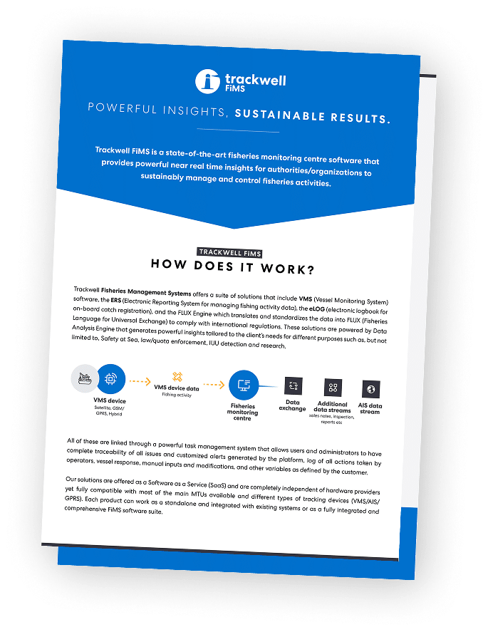
VMS units: these devices are installed in the vessels and communicate de positional information via satellite and/or GSM network and device originated events such as power shortage tampering alerts, antenna blockage and many others. In some cases, they also can generate emergency alerts from a panic button. The VMS devices can also be used to transmit other type of information coming from onboard devices to the VMS monitoring software installed in the Fishing Monitoring Centre (FMC) on shoreside. These units are installed in the vessel and require very little servicing. If the units require power from the vessel, they will need proper installation and cabling requiring more aftersales maintenance or servicing related to the installation, while solar powered units are usually self-installed by the vessel owner and require very little to no later service. All information coming from the device through the satellite network is retrieved by the FMC software from the VMS unit provider’s gateway and not directly to from the unit to the FMC software. The pricing policy from the VMS device providers is based on volume or number of units.
Airtime services: to be able to transmit the positional data, or any other additional data, the units require to subscribe to a data plan which can be satellite only, GSM/GPRS only or hybrid depending on the needs in relation to the cellular coverage of the area and the characteristics of the fishing fleet and type of fisheries. It’s important to notice that nowadays the satellite costs are much more competitive now so there is not necessarily a cost advantage with hybrid units compared to satellite only units. The airtime services are based in data plans that account for a certain amount of data, plus an overage cost in case the consumption is higher than expected. This higher data consumption than planned can be caused if the authorities decide to increase the reporting frequency of one or more vessels, but this can be controlled and administrated by the authorized operators through the FMC software platform if the unit is compatible with this functionality. Airtime plans are sold together with the VMS units by the device providers who in many cases act as re sellers for the satellite companies, and their pricing policy is also based in volume (number of units and amount of data in each plan)
AIS positional data: automatic Identification System (AIS) positional data is generated by the AIS units that are installed on most large vessels in the world as a basic requirement. AIS units emit a VHF signal that reports the location, speed and heading of the vessel in short intervals and it is received by nearby vessels to avoid collision. The AIS messages generally does not carry any other type of data additional to the one it is designed for, only providing the positional data, speed and heading alongside with some parameters related to the AIS unit itself. These signals are also received by land stations/antennas installed along the coastlines of many countries and by satellites. The AIS data feed for a certain area can be purchased from one of the few main AIS data providers who own a network of satellites and land stations in many countries. Many VMS systems integrate this AIS data into their FMC software to complement the VMS data, and in some cases the VMS system can be based solely on AIS data if no VMS units are installed in the vessels. The AIS data feed is provided as a service and is paid in a monthly fee.
FMC software, maintenance, and support
The FMC software or also known as VMS Software, such as Trackwell, is the key element that must integrate the information, and generate the necessary insights to monitor the vessels, direct the enforcement and safety at sea tasks and overall management of the fisheries. The system must also provide the necessary compliance to international regulations with data governance mechanisms that are highly complex in most cases. This software is most commonly offered as a Software as a Service (SaaS) since they are the result of extensive software development and require continuous maintenance, updates and 24/7 support services to keep the whole system fully operational.
The system can be hosted both in local servers or in a cloud, but best practices in the industry suggest to always host the system in a cloud environment. Cloud environments are easier and cheaper to operate and maintain, they include the use of database licenses which are otherwise very costly, and provide cutting edge backup systems and disaster recovery measures to ensure the uptime rate needed for this mission-critical type of systems, while also complying with the highest data security standards.
Apart form the more standard functionality, the FMC software can also provide other additional more complex functionality that will affect the license and service cost.
- Data governance capabilities. Many VMS systems in the world are shared by different states of one country, granting access only to subsets of information to each state, or accessed by different countries like the case of the VMS systems from Regional Fisheries Management Organizations (RFMOs). To allow this, complex data governance mechanisms need to be added as a fully customized solution to the specific client to guarantee that each stakeholder has access only to their respective information within the system, affecting the commissioning cost and maintenance of such mechanisms.
- Data sharing in fisheries specific formats, particularly FLUX (Fisheries Language for Universal Exchange). FLUX is the UN standard for data sharing in fisheries, currently being implemented as a mandatory requirement in the EU and gradually in the rest of the world. The main objective behind FLUX is to help detect and deter Illegal, Unregulated and Unreported (IUU) fishing by sharing fisheries data. The implementation of this data sharing and communications standard is highly complex and is also provided as a SaaS, additional to the FMC software.
- Data analysis tools. Further data analysis tools can be added to the system upon request e.g. fishing activity algorithms like fishing gear detection. This additional functionality is based on complex algorithms and machine learning techniques, impacting both the commissioning cost when requiring new functionality to be developed and added, and license cost for previously developed functionality.
Electronic Logbook (e-logbook) and Electronic Reporting System (ERS)
These components are optional modules that are used to integrate fishing activity information (related to catch) retrieved from the vessel and sent into the FMC software. The e-logbook can be an app or a client software that is used onboard the vessel for the fisherman or captain to log the catch information to comply to countries’ or regional regulations. This data is transmitted using the VMS unit communication plan (consuming more data and increasing the airtime cost) to the ERS module of the FMC software which receives, stores, and forwards the information accordingly.