Index of content
Illegal, Unreported, and Unregulated (IUU) fishing is a pervasive threat that undermines marine ecosystems, compromises global food security, and results in annual economic losses estimated in the tens of billions of dollars. To combat this, authorities require a reliable method to oversee vast stretches of ocean. The primary tool for this challenge is the vessel monitoring system, a dedicated surveillance solution that provides the necessary oversight to identify non-compliance and protect vital marine resources.
At its core, a Vessel Monitoring System (VMS) is a secure, satellite-based tracking solution designed specifically for fisheries management. Unlike public systems such as AIS, which can be turned off, a VMS is a mandatory and encrypted system for licensed commercial vessels. This distinction is crucial, as it makes VMS an indispensable tool for addressing IUU practices like fishing in closed zones, under-reporting catch, or operating without a license. It provides a constant, verifiable stream of data, turning the open ocean into a managed and accountable space.
How VMS delivers actionable intelligence
An effective Vessel Monitoring System delivers more than just location data; it provides the intelligence needed for proactive enforcement and sustainable management. The system is built on a reliable technical process and intelligent features that work together to create a comprehensive compliance picture, managed from a central command hub.
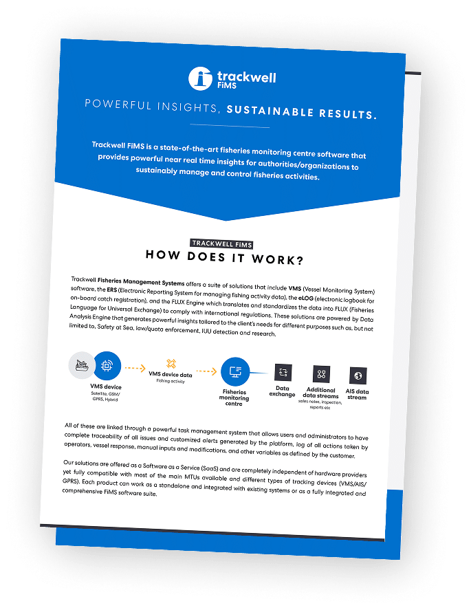
The core Vessel Monitoring System process: from vessel to control center
The VMS process operates through a seamless, three-part flow of information. It begins on the vessel with a certified, tamper-proof onboard VMS transponder. These units are built to strict technical standards to prevent interference and ensure they are always active, automatically collecting and encrypting crucial data—such as GPS location, course, and speed—at regular, predetermined intervals.
Key capabilities for proactive enforcement
The true power of a VMS is realized when its tracking data is transformed into clear, actionable insights. This added value comes from highly sophisticated Fishing Monitoring Centre (FMC) software that receives, processes and analyses the data coming from the VMS transponders. The system allows authorities to establish automated geofencing alerts, which trigger an instant notification if a vessel enters a Marine Protected Area (MPA), a seasonal closure, or another nation’s waters without authorization. More complex alerts are also crucial, such as being able to identify illegal transhipment, fishing patterns that belong to unauthorized fishing gear and more.
Building a Foundation for Sustainable Governance
By implementing a robust VMS, authorities are not just adopting a technology—they are building the foundation for transparent governance and long-term marine sustainability. It is a critical compliance infrastructure that enables smarter patrol planning, data-driven policymaking, and a powerful deterrent through constant visibility. As illegal fishing operations become more sophisticated and the impacts of climate change alter marine environments, the move towards predictive analytics and fully integrated data ecosystems will become even more critical.
Frequently asked questions (FAQ)
How customizable is the alerting system for geofencing and behavioral analysis?
Highly customizable. An advanced platform like Trackwell FiMS allows authorized users at the Fisheries Monitoring Center (FMC) to create, modify, and assign rules on the fly. You can set up specific alerts for entry into any custom-defined zone (e.g., spawning grounds, buffer zones), for specific speed thresholds, or for complex behavioral patterns without needing vendor intervention.
Beyond GPS data, what other information can be integrated into the VMS platform?
A modern VMS software serves as an integration hub. Beyond the core vessel tracking data, it is designed to seamlessly integrate with Electronic Reporting Systems (ERS) for catch data, vessel licensing databases, quota management systems, and sales notes allowing a comprehensive view of fishing operations.
What happens if a vessel operates in an area with intermittent satellite coverage?
The onboard VMS transponders are designed to handle this. If a satellite link is temporarily unavailable, the unit will continue to securely store the collected position reports in its internal memory. Once a connection is re-established, it automatically transmits the entire backlog of stored data to the FMC, ensuring there are no gaps in the vessel’s activity track.
What kind of training and support is available for our fisheries officers and control center staff?
Comprehensive support is crucial for effective implementation. This typically includes initial hands-on training for all users on the VMS software, from basic monitoring to advanced analysis. Ongoing support is also provided through dedicated technical assistance channels to help with any operational questions, troubleshooting, or requests for system adjustments.
How is Vesel Monitoring System data stored and how long is it retained?
All incoming VMS data is stored on secure, redundant servers, ensuring its integrity and availability for both legal and scientific purposes. Data retention policies are typically determined by national or regional regulations, but the system is capable of archiving data for many years to allow for long-term historical analysis, stock assessment studies, and building legal cases.
What is the typical process for getting a national or regional fleet equipped with VMS?
The process usually begins with a needs assessment and consultation to define the scope of the project. This is followed by the selection and type-approval of VMS transponders. A phased rollout plan is then created for installing the hardware on vessels, while simultaneously setting up the software at the FMC. The final step involves training the end-users and formally launching the system.