Vessel Monitoring Systems (VMS) are critical tools for fisheries authorities, coast guards, and enforcement agencies to track and monitor licensed vessels in near real time. By securely collecting position reports and operational data via satellite, GPRS, and AIS, VMS technology enables compliance monitoring, helps detect illegal, unreported, and unregulated (IUU) fishing, and improves safety at sea. These systems play a vital role in protecting marine resources, managing fishing quotas, and ensuring the long-term sustainability of fisheries.
Trackwell VMS is the dedicated vessel monitoring solution within the Trackwell FiMS (Fisheries Management System) platform. Deployed in Fisheries Monitoring Centres worldwide, it delivers precise, near real-time tracking data and powerful analytical tools for enforcement, safety, and fisheries management.
The system integrates all vessel data into an intuitive, user-friendly interface—helping authorities respond faster, operate more efficiently, and make informed decisions backed by reliable information.
Trackwell VMS is offered as Software as a Service (SaaS), covering licensing, preventive maintenance, updates, and 24/7/365 support. With disaster recovery and backup protocols, and uptime of over 99.95%, authorities can rely on continuous operations under any conditions.
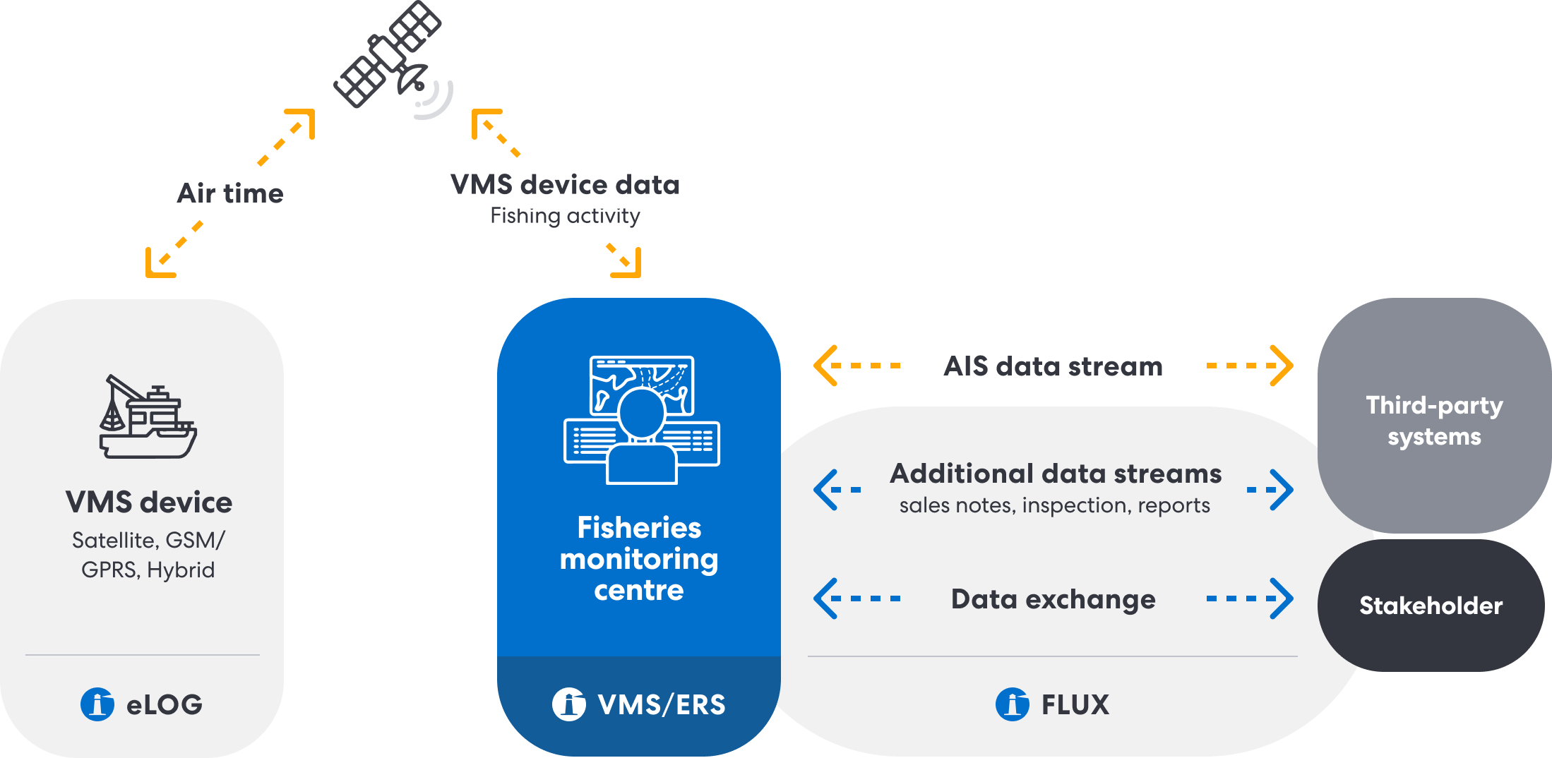
Vessel position and activity data from satellite, GSM/GPRS, or hybrid VMS devices is sent to Fisheries Monitoring Centres, where it is combined with AIS positional data, inspection reports, sales notes, and other operational records.
This combined dataset is securely shared via the FLUX (Fisheries Language for Universal Exchange) network and can be integrated with third-party systems and key stakeholders. This ensures transparent reporting, regulatory compliance, and effective fisheries management.
Trackwell VMS goes beyond displaying dots on a map—it delivers the advanced functionality modern monitoring requires: customizable alerts, cross-checking of multiple data layers, and full audit trails for complete traceability.
The platform generates actionable insights that help authorities actively monitor fisheries activities, prioritize enforcement, and improve safety at sea. Automated, customizable alerts ensure quick responses, while integration with weather and oceanographic forecasts adds valuable context for operational decisions.
Trackwell VMS is more than a tracking tool — it’s a complete operational platform for real-time monitoring, compliance, and decision-making in fisheries management. It combines advanced mapping, fleet management, licensing, reporting, and integration capabilities in one secure, user-friendly system.
The system is web-based application that provides an intuitive and easy to use user interface, accessible from both desktop and mobile devices with an internet connection and a standard web browser. The Monitoring page organizes all issues and alerts, giving users a complete overview of operations and making their work faster and more efficient.
Vessel locations are presented on a state-of-the-art map application, supporting navigational maps in most standard formats. Features include vessel filtering, user-defined maps, geofence (digital boundary) editor, history trails, and replay functions for detailed analysis of vessel behavior. The system can also integrate weather and oceanographic forecast layers.
All vessel information is one click away. Vessel positions are displayed in near real time, while device events such as tampering alerts or distress calls are automatically processed and prioritized for operator action. Trackwell VMS provides cutting-edge analysis capabilities, improving decision-making and saving time and resources in monitoring, law enforcement, and safety operations.
Users can configure any number of monitoring requests with advanced alert mechanisms. Alerts can be set up for all vessels, predefined groups, dynamically calculated groups (by nationality, type of fishing, etc.), or for individual vessels. The system processes zone data in real time, enabling geofencing alerts and cross-checking multiple data sources to identify issues accurately.
Trackwell VMS provides robust tools to combat IUU fishing. Authorities can monitor reserved fishing zones, marine protected areas, and other regulated areas. The system integrates data from fishing license databases, seaworthiness certificates, and other records, enabling better enforcement and protection of fish stocks. With sustainable fisheries management, marine resources can recover and thrive.
Trackwell VMS monitors vessel entry/exit from harbors and issues alerts if a vessel stops reporting outside a harbor zone or fails to report on schedule. Distress signals from vessels trigger customized alarms, helping authorities prioritize safety-related tasks.
The system manages the entire database of vessels and their information. Functions include searching, listing, and editing vessel data (name, position, history, speed, registrations, licenses, authorizations, etc.). The registry can also sync automatically with external national databases.
Fishing licenses and permits can be integrated into the registry and synchronized with external databases. Authorized users can assign, update, suspend, or manage licenses and permits according to specific requirements.
The system generates predefined reports with flexible filters. Custom reports can also be created as needed. Reports can be exported in Excel, PDF, or Word formats.
The ERS (Electronic Reporting System) module integrates seamlessly with Trackwell VMS or functions as a standalone product. It processes fishing activity data, sales notes, and other fisheries-related information from Trackwell eLog or third-party logbooks.
User profiles are secured with standard credentials and role-based access controls (admin, user, guest, or custom roles). All activities are logged in full audit trails.
Trackwell VMS enables shared usage, granting access only to subsets of data when required (e.g., for RFMOs or multi-state authorities). Complex governance mechanisms can be customized per client.
Trackwell ensures the highest levels of security and reliability, meeting the stringent requirements of governments and RFMOs.
The system accommodates fleets from tens to thousands of vessels, whether national, regional, or international. There is no limit on the number of users.
Trackwell VMS integrates with the Trackwell FLUX Engine to distribute fisheries-related data through the FLUX network. The FLUX Engine can also integrate with other FMC systems.
The system supports all major protocols and message formats required by the EU, regional fisheries organizations (e.g., NEAFC, NAFO, SEAFO, ICCAT), and bilateral agreements between countries.
Trackwell VMS can integrate Automatic Identification System (AIS) data to complement VMS device data. In some cases, systems may rely solely on AIS data when VMS units are not installed. AIS feeds are available via third-party providers or national AIS networks.
Trackwell VMS is hardware-independent. Support for new transponder models or service provider gateways is routinely added. The system supports all major device types (satellite, GSM/GPRS, hybrid).
Our Marine Vessel Monitoring System meets the highest fisheries control standards and supports transparent reporting through the FLUX network, enabling cooperation between nations and organizations.
Customers worldwide rely on Trackwell FiMS to strengthen compliance, enhance operational safety, and promote environmental sustainability. We are proud to have earned the trust of leading organizations and countries, including Iceland, NEAFC, NAFO, Albania, the Pacific Islands Forum Fisheries Agency (FFA), the Western and Central Pacific Fisheries Commission (WCPFC), Australia, and Malta—supporting them in the development and continuous improvement of fisheries information management systems.
Find out what FiMS can do for your organization-business!
Please, get in contact with our team and you will receive a link to download our brochure.
About us
Trackwell FiMS is a state of the art software that provides powerful near real-time insights to sustainably manage and control fisheries activities.

Fisheries Management System
Helpful links