Modern fisheries monitoring is no longer just about vessel positions. Maintaining Situational Awareness at Sea has become a fundamental need as weather patterns grow more unpredictable and maritime operations become more complex. Fisheries Monitoring Centres (FMCs) require a clearer, more complete picture of what is happening at sea to ensure fleet safety.
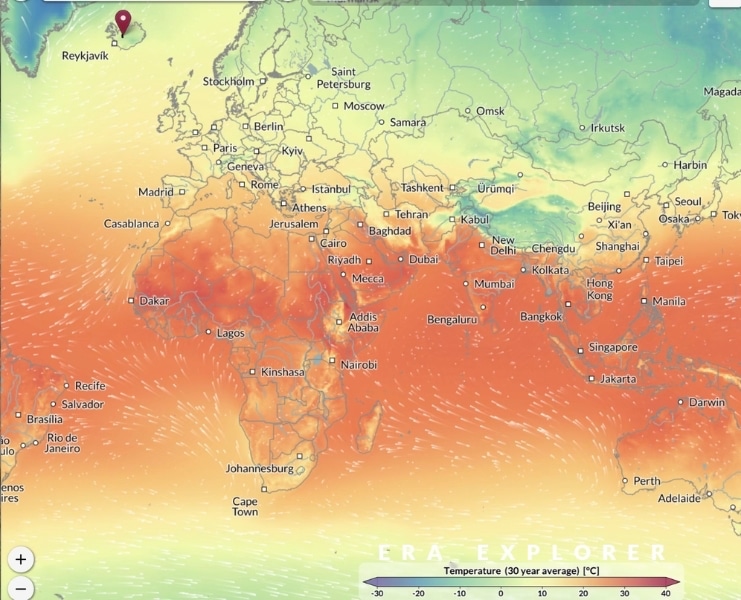
That’s why Trackwell FiMS supports the integration of oceanographic and weather data layers directly into the VMS interface, giving operators real-time environmental context alongside vessel activity. Trackwell sources its environmental data primarily Copernicus Marine Services and in some cases in relevant deployments through ORBCOMM. This seamless marine data integration ensures reliable, high-quality information for FMCs operating in diverse global regions.
Good Decisions Through Environmental Awareness
When FMC operators can view wind, wave height, sea state, currents, and storm systems directly alongside vessel positions, their ability to make informed decisions increases dramatically. This combined insight allows them to identify vessels operating in hazardous conditions, anticipate risks before they become emergencies, issue timely warnings to crews, and interpret unusual vessel behaviour that may be weather-related rather than suspicious. In regions where weather can change quickly, these environmental layers become essential tools for Maritime Situational Awareness rather than optional features.
Supporting Search & Rescue Operations
Environmental data is especially valuable during search and rescue (SAR) events. When operators can view both vessel tracks and real-time ocean conditions, they are better equipped to assess a vessel’s last known position and estimate drift patterns based on currents and wind direction. This allows monitoring centres to coordinate more effectively with coast guard and rescue authorities, narrow down search areas, and respond more quickly. The combination of marine VMS activity and oceanographic insight can significantly improve the speed and accuracy of SAR operations when every minute counts.
A Multi-Layered Platform for Modern Fisheries Monitoring Centres (FMCs)
Trackwell FiMS has a map which can incorporate data, in most cases from Copernicus and in some installations from ORBCOMM. FMC operators can switch layers on and off, combine multiple data sources, and view forecasts, within the same interface they use for daily monitoring.
This flexibility gives authorities a more complete operational picture, strengthening both safety at sea and the efficiency of their monitoring activities.
Weather, Ocean Data, and VMS — Better Together
Integrating oceanographic and weather information with VMS improves safety, enhances situational awareness, and supports faster, more informed responses. Many of Trackwell’s customers are already using these environmental data layers with excellent results, helping their FMC operators manage changing conditions more effectively. For authorities working to protect both their fleets and their waters, these insights are becoming an essential part of modern fisheries management system.